The MPIC had an excellent speaker on Wednesday night from Greater Worcester Land Trust (http://www.gwlt.org). Colin M.J. Novick, the project Coordinator for GWLT spoke energetically for about an hour. The purpose of the meeting was to have an informational discussion of conservation, how they went about it in Worcester, successes and failures and such. The idea was to partially test the waters for what the town could do in this regard.
It's a shame it wasn't televised, because there was a lot of information, but in essence he went through their results in maps and on a slide presentation (will try and get a link to the information) as well as some of how they did it. They started in 1987 and continue to this day, preserving around 1500 acres of open space in the city. It doesn't sound like a lot but given it's mostly in an urban area it's certainly something to be proud of.
Conservation takes a lot of time and commitment. For the first 3 years, no land at all was saved from development. This was partially because of a real estate boom at the time. I quipped at one point that on the bright side we're in a downturn which would make things easier. But over time, given their persistent efforts and presence, opportunities arose. One action they took that made a lot of sense was in the beginning they identified the 15 top parcels or opportunities and tracked them over time. They went out and knocked on doors to discuss what the owners wanted, were patient and found funds both in the trust and at all levels of government.
There are many ways to accomplish conservation besides owning the land. Conservation restrictions for instance, allow someone else to own the property while providing some agreed upon conservation level and management. The owner gets special tax consideration for this which saves them money while preserving the land from development. Trail easements across private land are a way to link conservation tracts and in MGL liability is very limited.
Most if not all conservation done by GWLT allows some degree of public access. This is mostly passive recreation but not always (for instance Green Hill Park which has a golf course and armory on it). But the goal is usually to preserve the land from development while allowing things like walking or hiking, not motorized vehicles and such. So folks can enjoy it but at the same time keep the character of the habitat or landscape and not destroy it.
There are at least 3 things that can be done in a given town - formation of a 501c3 corp like GWLT, use the assistance of a group like that on a limited basis or have a town-based organization. The reason a completely government-based org isn't good is that to a lot of people that seems intrusive or negative. If you're a non-profit, people are much more likely to work with you and trust you (since you have no money for one).
Ann Weston mentioned many 61a (farming) properties as well as other town owned land which are opportunities for conservation. Also the Auburn Hills project was again mentioned for possible land gift to the town should they decide to go with the open space plan. In this case, it might make sense to get outside help of GWLT or another organization because things could happen very quickly.
The bottom line is that people have to care about parcels to succeed in preserving them. The director really has a positive attitude, keeps up to date on which grants are available and is willing to wait and work with various parties to get things done. Obviously, his energy helps tremendously, but he also made a point to explicitly credit his platoon of volunteers for all the efforts they make. Land will be preserved by those who use it now or remember it from when they were kids and enjoyed it and those who value keeping some natural features about the place safe from development. There are incentives to landowners for this also but it's really the commitment of volunteers that make this work over time.
Contact me if you're interested in this topic, I will be trying to garner support for it and testing the waters for interest. I think a place to start will be the Concom also groups like the Sportsmen's club and other organizations in town.
Showing posts with label conservation. Show all posts
Showing posts with label conservation. Show all posts
Thursday, September 20, 2007

Tuesday, August 7, 2007
Conservation (for other towns); Auburn and Blackstone watershed
Nice article on some conservation gains nearby in the T&G today. Note it mentions drinking water in Auburn
The 75 acres of tree farm, lawn, meadow, trails and woodland where a restored farmhouse stands and where a brook runs toward Holden Reservoir No. 1 is forever preserved as conservation land.
Yesterday morning, it was the site of a multi-agency celebration of three properties recently set aside by private and government efforts to protect drinking water supplying Worcester, Holden, Paxton, Auburn, Millbury and West Boylston.
Just a little background - the brook I think is Tatnuck, which ends up with Kettle and Dark Brooks (of which I've seen two descriptions in town, one by the golf range and one connecting Dark Brook Res to Lower Stoneville) to drain into the Blackstone.
Here's one map from the Blackstone River Coalition that shows the area.
And another from the Blackstone Headwaters Coalition (at Clark U). More specifically, Kettle and Dark Brook drainage.
Funny I never see our Conservation Commission prominent on any of these issues. We're part of the Blackstone watershed, you'd think they'd be involved, even the AWD since they obtained land for wells on Silver St recently, near Kettle Brook.
The 75 acres of tree farm, lawn, meadow, trails and woodland where a restored farmhouse stands and where a brook runs toward Holden Reservoir No. 1 is forever preserved as conservation land.
Yesterday morning, it was the site of a multi-agency celebration of three properties recently set aside by private and government efforts to protect drinking water supplying Worcester, Holden, Paxton, Auburn, Millbury and West Boylston.
Just a little background - the brook I think is Tatnuck, which ends up with Kettle and Dark Brooks (of which I've seen two descriptions in town, one by the golf range and one connecting Dark Brook Res to Lower Stoneville) to drain into the Blackstone.
Here's one map from the Blackstone River Coalition that shows the area.
And another from the Blackstone Headwaters Coalition (at Clark U). More specifically, Kettle and Dark Brook drainage.
Funny I never see our Conservation Commission prominent on any of these issues. We're part of the Blackstone watershed, you'd think they'd be involved, even the AWD since they obtained land for wells on Silver St recently, near Kettle Brook.
Friday, August 3, 2007
What some towns are doing about Open Space
Wow - imagine that, a town conserving open space from development - actually buying land for it too.
http://telegram.com/article/20070803/NEWS/708030655/1101
HOLDEN— As volunteers and government officials prepare to celebrate their most recent land preservation successes, another group is forming to block sprawl development on key expanses of land.
With much of the land east of Central Massachusetts already covered with buildings, local conservation volunteers and professionals are predicting a rush of development in the center of the state.
To prevent development from overtaking open land, some local residents are urging the hiring of land procurement and preservation specialists to focus on Central Massachusetts.
The plan will be announced during Monday’s celebration, according to Anthony J. Costello of the White Oak Land Conservation Society.
All the pols will be there
U.S. Rep. James P. McGovern, the White Oak Land Conservation Society, U.S. Forest Service, state Department of Conservation and Recreation, the Worcester Department of Public Works, the Executive Office of Environmental Affairs and the Trust for Public Land will come together at 10:30 a.m. Monday
Here's a novel idea
Mr. Crater agrees. “The way I look at it, Central Massachusetts is a beautiful area and we have such value in our little towns .... We have so much to lose here if we’re not careful.”
http://telegram.com/article/20070803/NEWS/708030655/1101
HOLDEN— As volunteers and government officials prepare to celebrate their most recent land preservation successes, another group is forming to block sprawl development on key expanses of land.
With much of the land east of Central Massachusetts already covered with buildings, local conservation volunteers and professionals are predicting a rush of development in the center of the state.
To prevent development from overtaking open land, some local residents are urging the hiring of land procurement and preservation specialists to focus on Central Massachusetts.
The plan will be announced during Monday’s celebration, according to Anthony J. Costello of the White Oak Land Conservation Society.
All the pols will be there
U.S. Rep. James P. McGovern, the White Oak Land Conservation Society, U.S. Forest Service, state Department of Conservation and Recreation, the Worcester Department of Public Works, the Executive Office of Environmental Affairs and the Trust for Public Land will come together at 10:30 a.m. Monday
Here's a novel idea
Mr. Crater agrees. “The way I look at it, Central Massachusetts is a beautiful area and we have such value in our little towns .... We have so much to lose here if we’re not careful.”
Friday, July 27, 2007
No plan for open space here
One of the areas I think the town has neglected recently is the issue of open space. This is both true in the larger sense but also a more immediate one. We used to have, in accordance with MGL (Massachusetts general laws) c41 with respect to the Master Plan:
Massachusetts Statutory Requirements
M.G.L. c41, §81D requires that in the preparation of a Master Plan, a planning board (and the community) shall include the following elements:
Open space and recreation element which provides an inventory of recreational resources and open space areas of the municipality, and policies and strategies for the management and protection of such resources and areas.
Here is the old open space plan, which is now defunct since August 2005:
http://www.auburnguide.com/template2.pl?id=138,56,36
In case the link evaporates mysteriously as things tend to do around the Town Hall it's under the section Home>Culture>Natural Resource Planning. Quoting from the plan:
Goal 2 To expand and improve existing open space and recreational resources and facilities.
Objectives
• Improve existing recreational facilities as per the Parks Master Plan.
• Provide a wider variety of recreational activities of people for all abilities, including expanded opportunities for hiking, biking, swimming, canoing, fishing and bird watching.
• Develop trails for both passive and active recreational use
• Develop a multi use plan for the Pakachoag Meadows and Grace Cutting Park parcels.
• Develop a trail from the Housing Authority land around the Senior Center.
• Improve accessibility of existing public open space to all segments of the community, including the addition of access easements, parking facilities and trail systems.
• Protect and/or acquire surface water bodies that provide recreational opportunities.
• Provide aesthetic improvements to existing parcels, particularly Gleason Park and Rotary Beach.
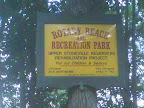
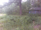
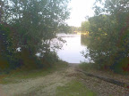
there's not much going on. In fact when I brought the issue of Rotary Beach up at a recent Recreation meeting, it was dismissed out of hand as unusable. It's curious that somehow the waterway has deteriorated to the point it's unusable in 2007 yet in the previous incantation of the open space plan from 2000 it was worth maintaining at least.
Well it turns out grant money requested for the new Rec director's plans for fields over on Packachoag may not be available in part because we don't have a current open space and recreation plan filed with the state. This is a requirement under the above statute to receive funds.
There are several other goals listed in the old open space plan like a nature education center, walking trails and such, all of which to my knowledge have been left aside for another time and set of people to worry about. A much greater opportunity for open space preservation, a proposed gift by a developer of an area of just under 300 acres of prime uplands on Leicester St recently received an unenthusiastic response from Planning claiming “that land is of no use to the town because we can't build on it or provide athletic fields from it”. I've walked that land and it's essentially wild, perfect for passive (ie low cost) recreation and habitat preservation. Open space is simply not a priority in town right now, thanks to a development-centered mentality. Issues of conservation are viewed mostly as a hurdle to overcome in your site planning process. There has been very little in the way of proactive conservation or passive recreation planning, although the recent Master Plan approved by town meeting did mention some goals for preservation in a general way.
Upon contacting other towns like Charlton and Millbury, a statement was made that Auburn is like the donut hole as far as conservation efforts. Surrounding towns have the Charlton Heritage Trust and Millbury has conservation land. It wouldn't take a huge effort for our town to have the same. In fact contrast that with expensive and energy intensive areas like athletic fields and there's no contest – passive recreation is far lower cost over time. The overall character of the town is intricately connected to undeveloped land also. One of the few open areas that exists for conservation is private – the Auburn Sportsman's Club. I think we should be grateful they have not sold out and cashed in all these years, but it also points to the lack of public lands available.
Open space zoning when you don't preserve it
There's another side to the open space issue namely zoning, which is somewhat controversial to some people. The idea is that planning development in tight nit clusters is more efficient, lessens the impact of sprawl on the environment and when done properly ensures more open space is preserved. There are economic benefits (better market value) also for the home owners when it's done properly. One key issue that enables this is that because we have town sewer and water we can do it. On the face of it I think this is a good idea in many ways. Given the fact that the town is relatively small geographically, the presence of several bodies of water and otherwise limited suitable land for residential building, it kind of makes sense also.
The reason people don't like it many times is that for one, things tend to get more crowded. Some folks want a large minimum lot size and like that feeling of having a large piece of land they can call their own. But this also can lead to sprawl, destruction of trees and habitat, eutrophication of waterways, increased impervious surfaces (leading to drainage issues) and higher cost for services due to less of a tax base. On the other side of it, if open space planning is done properly it should in theory add a sense of community to neighborhoods that do it as well as economic benefits due to preserved space and character.
I think the problem with this in our town is that, other than wetland areas, which are not really buildable (although they've filled plenty in, biggest example being Silver Lake/Auburn Mall), open space is not really planned for, it's what is left over. This kind of makes sense since we don't have a plan right now. The economic benefits for homeowners of open space clusters are not there unless you preserve the rest of the space from development. The result right now is houses built in areas like under power lines, in low lying gullies and ditches – spots that don't make a lot of sense. I think developers take maximum advantage of our tight zoning to fit in as much as possible. Unless and until with open space planning and clustering we actually preserve space, you just urbanize the community. Granted this is efficient in terms of delivery of services and extending the tax base; but over time, Auburn would become more and more an extension of the city of Worcester, unless we plan to preserve those things that make us a town. The hills, waterways, woods and fields of Auburn, are what gives it its character as a town and what we'll give up if we let open space planning continue without preservation or conservation.
Subscribe to:
Posts (Atom)